|
|
|||||
|
|
|||||
|
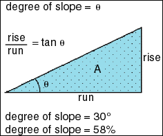
Slope The concept of measuring slope from a topographic map is a familiar one for most professionals in the landscape planning/surveying professions. Slope is a measurement of how steep the ground surface is. The steeper the surface the greater the slope. Slope is measured by calculating the tangent of the surface. The tangent is calculated by dividing the vertical change in elevation by the horizontal distance. If we view the surface in cross section we
can visualize a right angle triangle: Slope is normally expressed in planning as a percent slope which is the tangent (slope) multiplied by 100 Percent Slope = Height
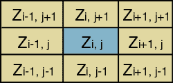
/ Base * 100 This form of expressing slope is common, though can be confusing since as 100% slope is actually a 45 degree angle due to the fact that the height and base of a 45 degree angle are equal and when divided always equals 1 and when multiplied by 100 equals 100%. In fact slope percent can reach infinity as the slope approaches a vertical surface (the base distance approaches 0). In practice this is impossible in a gridded database since the base is never less that the width of a cell. Another form of expressing slope is in degrees. To calculate degrees one takes the Arc Tangent of the slope: Degrees Slope = ArcTangent (Height / Base) NB. ArcView calculates slope as degrees What is important to understand is that we can measure the slope of any surface, defined by measures of topography, temperature, cost or other variables. We can take the slope of the surface defined by air pressure measurements on a weather map to find where the pressure is changing rapidly-this tells us the location of weather fronts. If we take the slope of a slope map it tells us how fast slope is changing. This is equivalent to taking the second derivative of a surface. On a topographic map this is a measure of surface roughness which can be an important factor in estimating the cooling effects of breezes on micro-climates. (Rough surfaces create turbulence and mixing of air masses of different temperatures. This creates better cooling effects at the surface of the ground.) Using these examples it is useful consider slope as a measure of change in a surface. When measuring slope in a GIS the input map must be an interval map which represents a surface as a set of continuous (floating point) values. The output is interval. Methods for calculating slope, aspect and hill shading in a raster GIS The gradient of slopes is calculated from a 3 x 3 cell window as shown below. The window below represents the eight neighbouring elevations (Z) surrounding the cell at column i row j . Figure 2 shows the window (kernel) used for computing derivatives of elevation matrices. This 3x3 window is sucessively moved over the map to give the derivatives slope and aspect.
If average slope is requested, east west gradients are calculated as follows dEW= [(Zi+1,j+1 + 2Zi+1,j + Zi+1,j-1) - (Zi-1,j+1 + 2Zi-1,j + Zi-1,j-1)]/8dX The north-south gradient is calculated by dNS = [(Zi+1,j+1 + 2Zi,j+1 + Zi-1,j+1) - (Zi+1,j-1 + 2Zi,j-1 + Zi-1,j-1)]/8dy Where Percent slope is calculated by: Slope% = 100 * [(dEW)^2*(dNS)^2]^1/2 Degrees slope is calculated by: SlopeDegrees = ArcTangent[(dEW)^2 +(dNS)^2]^1/2 Maximum slope is calculated from the maximum gradient of 8 neighbours. NB. ArcView calculates slope this way with the result in degrees. Maximum downhill slope is calculated from the maximum gradient of the cell or cells that are less than or equal in elevation to the central cell. If there is no downhill neighbour the cell is assigned a value of -1.
|
|
| Click here to download all Theory presented in this Module | |
| references | |
|
|