|
|
|||||

|
|||||
|
|
|||||
|
|
|||||
|
Introduction The earths surface is a continuous phenomena. There are various ways of representing such surfaces in digital form using a finite amount of storage. Digital elevation models are used as a way of representing surfaces. A DEM is a quantitative model of a topographic surface in digital form. The term digital elevation model or DEM is frequently used to refer to any digital representation of a topographic surface, however, most often it is used to refer specifically to a raster or regular grid of spot heights. Digital terrain model (DTM) is also used to refer to any digital representation of a topographic surface. The DEM is the simplest form of digital representation of topography and the most common. The resolution, or the distance between adjacent
grid points, is a critical parameter of any DEM. The best resolution
commonly available is 30 m. The data sets should be visualized as continuous
surfaces. The operators we will discuss here are designed to work on
any continuous surface e.g. map elevations, temperature gradients, or
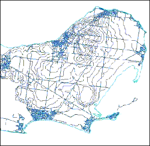
cost surfaces. Elevation Data Elevation
data is used to create DEMs. A figure showing contour data is shown
below. The first shows contour data as a set of lines which connect
places of equal height.
|
|
| Click here to download all Theory presented in this Module | |
| references | |
|
|