|
|
|||||
|
|
|
index
Cartographic modelling is a general, but well-defined methodology that is used to address diverse applications of GIS in a clear manner. It is a technique used for both vector and raster based GIS, and as the term suggests, cartographic modelling involves models (ie. of geospatial information) represented in cartographic form (ie. as Maps). Cartographic modelling is used to simultaneously analyse both the spatial and thematic characteristics of geospatial information. The thematic component of geospatial information is analysed via statistical operations on the data (for example, taking the Average and Standard Deviation of the data), where the spatial characteristics of geospatial information are described through spatial analysis techniques (which are based on coordinate data).
Geographical Information Systems are used to perform a number of fundamental spatial analysis operations, such operations can use any number of analytical processes. However almost all spatial analyses utilise six fundamental operations: Topological Map Overlay, Buffer Generation, Feature Extraction, Feature Merging, and the two relational database operations - Join and Relate. The main aim of this module is to clearly define and present the concepts and algorithms associated with topological map overlay processes, specifically in reference to vector based systems.
Topological map overlay creates new features and attribute relations by overlaying the features from two input map layers. Features from each input layer are combined to create new output features. Attributes of each input feature are combined from the two input layers to describe each new output feature, thus creating new attribute relationships. Often, the manipulation of multiple data layers is required to achieve the objective of the overlay operation. This is done in a stepwise fashion - two input layers are combined to form an intermediate layer, this intermediate layer is then combined with a third layer to form another intermediate layer, and so forth until the desired resultant map layer is achieved.
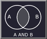
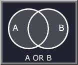
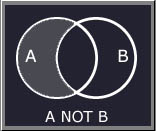
Boolean Algebra is useful for performing operations on the attributes (which may be positional or descriptive) attached to geographic entities in a GIS. Boolean Logic is especially useful in computing (or modelling) new attributes in topological overlay processing for both vector and raster based systems, as they can be applied to all data types, be they Boolean, Ratio, Interval, Ordinal, or Nominal. Boolean algebra uses the logical operators AND, OR, NOT to determine whether a particular condition is true or false. Each attribute can be thought of as defining a set. Consider two sets (set A and set B).
These simple relations can be visualised through the use of Venn diagrams.
For a GIS related example of the use of these boolean logical operations, enter the following link... Boolean Logic
- Simple Interactive Example
|
|||
|
|||
| Click here to download all theory presented in this module | |||
| References | |||
|
|
|||