|
|
|||||
|
|
|||||
|
Reclassification is a generalisation technique
used to re-assign values in an input raster layer to create a new raster
layer. Reclassification changes the value of the input cells on a cell-by-cell
basis within the area under analysis. This technique is commonly used to convert interval and ratio scale data into an ordinal ranking for landuse suitability modelling using map algebra. It has the additional benefit of reducing file sizes of raster layers.
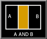
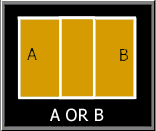
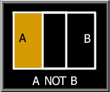
Map algebra creates new features and attribute relations by overlaying the features from two input map layers. Features from each input layer are combined to create new output features. Attributes of each input feature are combined from the two input layers to describe each new output feature, thus creating new attribute relationships. Often, the manipulation of multiple data layers is required to achieve the objective of the overlay operation. This is done in a stepwise fashion - two input layers are combined to form an intermediate layer, this intermediate layer is then combined with a third layer to form another intermediate layer, and so on until the desired resultant map layer is achieved. Map algebra uses boolean logic. Boolean Algebra is useful for performing operations on the attributes (which may be positional or descriptive) attached to geographic entities in a GIS. Boolean Logic is especially useful in computing (or modelling) new attributes in topological overlay processing for both vector and raster based systems, as they can be applied to all data types, be they Boolean, Ratio, Interval, Ordinal, or Nominal. Boolean algebra uses the logical operators AND, OR, NOT to determine whether a particular condition is true or false. Each attribute can be thought of as defining a set. Consider two sets (set A and set B):
For a GIS related example of the use of these boolean logical operations on raster datasets, follow this link: Boolean Logic - Simple Interactive Example |
|
| click here to download all theory presented in this module | |