|
|
MODELLING LAND USE DYNAMICS IN THE SPANISH NETWORK OF NATIONAL PARKS AND THEIR HINTERLAND (DUSPANAC) |
|
|
DUSPANAC GIS Documentation Chapter 1:Downloading, transforming, and clipping CORINE land cover data The objective was to create 3 CORINE Land Cover maps for each of the 14 national park areas. The principal problem was that the national park data was to be in LAEA (Lambert Azimuthal Equal Area) projection, based on the ETRS89 Datum, while National park boundaries were only provided (even for parts of Spain that do not normally use this Co-ordinate system) in European Datum 1950, UTM 30N. It was therefore necessary to : 1. Download the CORINE data 2. Clip the CORINE data for each of the three dates so that mainland Spain, the Baleares and Canarias were all included in a single map 3. Project the CORINE data correctly as LAEA. 4. Perform geodetic transformation on the park boundary areas to bring them into LAEA to allow the clip to be performed appropriately. 1: Downloading the data CORINE data were downloaded directly from the European Environment Agency (the old, interactive data download window at: http://www.eea.europa.eu/themes/landuse/interactive/clc-download has been decommissioned. This is a shame, since you could download the data for a window of your choice, and the data came correctly projected in LAEA.) I downloaded the following: 1. Corine Land Cover 1990 raster data - version 13 (02/2010) 2. Corine Land Cover 2000 raster data - version 13 (02/2010) 3. Corine Land Cover 2006 raster data - version 13 (02/2010) In each case I chose the 100m data, e.g. g100_06.zip/data-and-maps/data/ga-downloads/SH04UZP80M/corine-land-cover-2006-raster/g100_06.zip (ZIP archive 101.46 MB) These were then unzipped and added to a new data frame in ArcGIS 9.3 (running in virtualised windows XP sp 3 on a debian linux testing (squeeze) distribution) 2: Clipping the data I created a rough rectangle as a raster and used an Extract by Mask (spatial analyst tools-extraction-extract by mask) to clip the raster data to Spain. All done in about 40 minutes – this is not bad for large raster maps on a virtual machine, but I have since discovered that virtual box (I was using virtual manager before) will run xp much faster. 3: Projecting the data as LAEA The EEA data uses LAEA but comes in unprojected. The appropriate projection file provided with the downloaded dataset must be selected when bringing the data into ArcMap using the “Define projection” tool. In this case, I closed my previous ArcMap project and opened a new one to bring in the clipped datasets Now, in a new map window, bring in the corine raster data using “define projection”. Instead of accepting the default projection, select the one in the file provided with the download, called “ETRS_1989_LAEA_L52_M10.prj”. The map is then projected as LAEA based on the ETRS89 datum. Now the three landcover datasets we will use, CORINE 90,00 and 06, are introduced correctly with the appropriate map coordinate system. 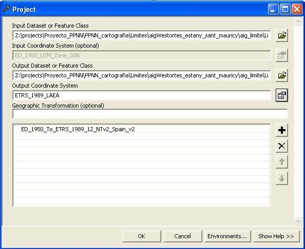 4: Performing a geodetic (datum) transformation on the National Park boundary data The next step, then, is to transform the ED1950 data (National park limits) to LAEA to fit with corine land cover maps we just projected. The procedure we used follows that described on the forum of Gabriel Ortiz , using the sped2et.gsb transformation grid. From the ArcTools menu (this can be done either in ArcMap or in ArcCatalog), select the Project tool to bring up the dialog box (left). In "Geographic Transformations", scroll down until you find ED_1950_to_ETRS_1989_12_NTv2_Spain_v2. In this way, each of park limits were transformed to ETRS89 LAEA (found in Projected Coordinate Systems – Continental – Europe – ETRS89 LAEA.prj)
|
 |
 |
 |